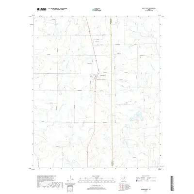
2019 Map of Windthorst
USGS Topo · Published 2019About this map
Windthorst serves as the central hub of this North Texas landscape, situated along the border of Archer and Clay Counties. The town's layout is closely tied to its religious and civic foundations, centered around the Po and the nearby Saint Mary Cem. This settlement pattern reflects a deeply rooted community where family surnames define the rural infrastructure, seen in roads like Weinzappel Loop, Munchrath RD, and Schroeder RD. The geography is defined by the drainage basins of W Little Post Oak Cr and E Little Post Oak Cr, which feed into the local reservoir at Windthorst Lake. This 2019 survey documents a landscape where agricultural heritage and modern connectivity intersect, maintaining the distinct grid-and-stream rhythm of the Texas plains.
Find a feature on this map
46 named features on this map. Tap any name to fly to it.
Don’t see what you’re looking for? This feature index may not catch every label — zoom into the map to look around manually.
Map Details
Editions of this 2019 Windthorst Map
This is the sole edition of this map. No revisions or reprints were ever made.
Other maps of this area

1931 · Archer City
USGS Topo · 1:62,500

1954 · Wichita Falls
USGS Topo · 1:250,000

1958 · Wichita Falls
USGS Topo · 1:250,000

1962 · Windthorst
USGS Topo · 1:24,000

1962 · Antelope Creek NE
USGS Topo · 1:24,000

1963 · Deer Creek
USGS Topo · 1:24,000

1963 · Scotland
USGS Topo · 1:24,000
1963 · Archer City NE
USGS Topo · 1:24,000

1963 · Archer City East
USGS Topo · 1:24,000

1964 · Darnell Branch
USGS Topo · 1:24,000