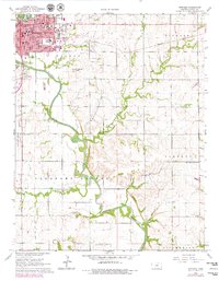
1965 Map of Winfield
USGS Topo · Published 1979About this map
Winfield serves as the regional hub in this mid-century survey, defined by its educational institutions and the winding course of the Walnut River. The town's grid is anchored by Southwestern College and St Johns College, with local landmarks like Irving Sch, Lowell Sch, and Whittier Sch marking the neighborhood structure. Outside the city limits, the landscape transitions into a mix of active industry and rural landmarks, notably the Winfield South Oil Field and the Seacat Oil Field, reflecting the era's energy economy.
Find a feature on this map
41 named features on this map. Tap any name to fly to it.
Don’t see what you’re looking for? This feature index may not catch every label — zoom into the map to look around manually.
Map Details
Editions of this 1965 Winfield Map
2 editions found
Other maps of this area

1889 · Burden
USGS Topo · 1:125,000

1890 · Wellington
USGS Topo · 1:125,000

1955 · Wichita
USGS Topo · 1:250,000

1958 · Wichita
USGS Topo · 1:250,000

1964 · Burden
USGS Topo · 1:24,000
1964 · Maple City
USGS Topo · 1:24,000

1965 · Silverdale
USGS Topo · 1:24,000

1965 · Arkansas City
USGS Topo · 1:24,000

1965 · Eaton
USGS Topo · 1:24,000

1965 · Winfield
USGS Topo · 1:24,000