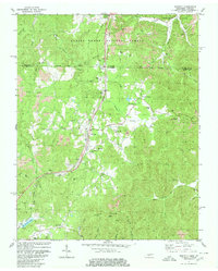
1980 Map of Winfield
USGS Topo · Published 1980About this map
The Southern railroad line serves as the primary spine for this region of the Cumberland Plateau, connecting the settlements of Winfield, Isham, and Strunk along the border between McCreary County, Kentucky, and Scott County, Tennessee. The landscape is defined by the sharp transition between the dense timber of the Daniel Boone National Forest and active extraction sites, with numerous strip mines and gas or oil wells dotting the hillsides. Local genealogy is well-preserved through a network of small family and community burial grounds such as Stephens Cem, Chitwood Cem, and Ross Cem. The rugged topography is drained by a complex system of waterways, including Roaring Paunch Creek and Bear Creek, which carve deep valleys into the terrain surrounding Honeycutt Mountain and Privet Mtn. Small centers of faith like Second Bethlehem Ch and Highway Ch anchor the rural crossroads and small clearings within the forest boundary.
Find a feature on this map
54 named features on this map. Tap any name to fly to it.
Don’t see what you’re looking for? This feature index may not catch every label — zoom into the map to look around manually.
Map Details
Editions of this 1980 Winfield Map
2 editions found
Other maps of this area

1890 · Williamsburg
USGS Topo · 1:125,000

1893 · Briceville
USGS Topo · 1:125,000

1894 · Williamsburg
USGS Topo · 1:125,000

1895 · Wartburg
USGS Topo · 1:125,000

1895 · Briceville
USGS Topo · 1:125,000

1896 · Wartburg
USGS Topo · 1:125,000

1896 · Briceville
USGS Topo · 1:125,000

1934 · Barthell
USGS Topo · 1:62,500

1936 · Pioneer
USGS Topo · 1:24,000
1946 · Pioneer
USGS Topo · 1:24,000