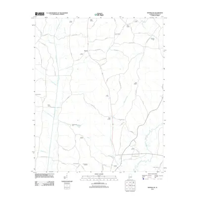
2011 Map of Winfield SE
USGS Topo · Published 2011About this map
The settlement of Stewart lies at the heart of this landscape, positioned along the upper reaches of Stewart Creek. The surrounding territory is defined by an extensive network of family and community cemeteries, including Hodges, Stewart Cemetery, and Ballard Cemetery, which provide significant data points for genealogical research in this part of Alabama. The local economy is marked by energy extraction, with the Bethel Church Gas Field and Studhorse Creek Gas Field appearing as prominent industrial features. The hydrography is dominated by the meandering course of the Sipsey River in the southeast and the southern flow of Luxapallila Creek to the west. Small-scale water management is evident at Watkins Lake Dam and Killingsworth Lake Dam, reflecting the local intersection of natural waterways and rural development in the early 21st century.
Find a feature on this map
72 named features on this map. Tap any name to fly to it.
Don’t see what you’re looking for? This feature index may not catch every label — zoom into the map to look around manually.
Map Details
Editions of this 2011 Winfield SE Map
This is the sole edition of this map. No revisions or reprints were ever made.
Other maps of this area

1953 · Birmingham
USGS Topo · 1:250,000

1956 · Birmingham
USGS Topo · 1:250,000

1957 · Birmingham
USGS Topo · 1:250,000

1967 · Bankston
USGS Topo · 1:24,000

1967 · Winfield SE
USGS Topo · 1:24,000

1967 · Hubbertville
USGS Topo · 1:24,000
1967 · Glen Allen
USGS Topo · 1:24,000

1967 · Bluff
USGS Topo · 1:24,000

1967 · Fayette
USGS Topo · 1:24,000
1967 · Winfield
USGS Topo · 1:24,000