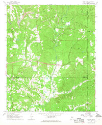
1967 Map of Glen Allen
USGS Topo · Published 1968About this map
The ST Louis San Francisco railroad cuts through the center of this landscape, connecting small rural hubs like Glen Allen and Texas at a time when coal mining shaped the local geography. Heavy industrial activity is evident in the numerous strip mines, mines, and an air shaft clustered around Rock City, illustrating the region's reliance on mineral extraction during the mid-20th century.
Find a feature on this map
46 named features on this map. Tap any name to fly to it.
Don’t see what you’re looking for? This feature index may not catch every label — zoom into the map to look around manually.
Map Details
Editions of this 1967 Glen Allen Map
3 editions found
Other maps of this area

1953 · Birmingham
USGS Topo · 1:250,000

1956 · Birmingham
USGS Topo · 1:250,000

1956 · Gadsden
USGS Topo · 1:250,000

1957 · Birmingham
USGS Topo · 1:250,000

1958 · Gadsden
USGS Topo · 1:250,000

1958 · Gold Mine
USGS Topo · 1:24,000
1958 · Lynn
USGS Topo · 1:24,000

1960 · Gadsden
USGS Topo · 1:250,000

1963 · Gadsden
USGS Topo · 1:250,000

1967 · Winfield SE
USGS Topo · 1:24,000