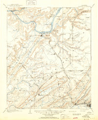
1963 Map of Gadsden
USGS Topo · Published 1963About this map
The Tennessee River corridor defines this mid-century landscape, linking the industrial centers of Florence, Sheffield, and Tuscumbia in the west to Huntsville and Gadsden in the east. By the early 1960s, the river had been transformed into a series of massive impoundments including Wilson Lake, Wheeler Lake, and Guntersville Lake, which reshaped the North Alabama shoreline. The expansion of Redstone Arsenal reflects the era's technological growth, while the Natchez Trace Parkway preserves an older transit corridor across the plateau.
Find a feature on this map
80 named features on this map. Tap any name to fly to it.
Don’t see what you’re looking for? This feature index may not catch every label — zoom into the map to look around manually.
Map Details
Editions of this 1963 Gadsden Map
This is the sole edition of this map. No revisions or reprints were ever made.
Historical Maps of Huntsville Through Time
9 maps found