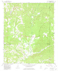
1967 Map of Glen Allen
USGS Topo · Published 1980About this map
Glen Allen sits at the intersection of Marion and Fayette counties, serving as a hub for the St Louis San Francisco railroad line which cuts through the southern Alabama hills. This 1967 survey reveals a landscape defined by both industrial extraction and rural community life, where Strip Mines and several Mines dot the northern ridges above the New River. The map captures the tight-knit nature of these hill-country settlements, marking small community anchors like Bazemore and Texas alongside numerous family-named burial grounds and churches.
Find a feature on this map
44 named features on this map. Tap any name to fly to it.
Don’t see what you’re looking for? This feature index may not catch every label — zoom into the map to look around manually.
Map Details
Editions of this 1967 Glen Allen Map
3 editions found
Other maps of this area

1953 · Birmingham
USGS Topo · 1:250,000

1956 · Birmingham
USGS Topo · 1:250,000

1956 · Gadsden
USGS Topo · 1:250,000

1957 · Birmingham
USGS Topo · 1:250,000

1958 · Gadsden
USGS Topo · 1:250,000

1958 · Gold Mine
USGS Topo · 1:24,000
1958 · Lynn
USGS Topo · 1:24,000

1960 · Gadsden
USGS Topo · 1:250,000

1963 · Gadsden
USGS Topo · 1:250,000

1967 · Winfield SE
USGS Topo · 1:24,000