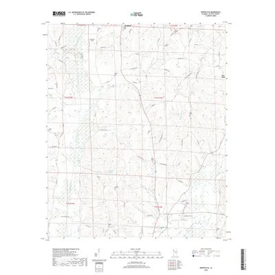
2018 Map of Winfield SE
USGS Topo · Published 2018About this map
Winfield and the neighboring community of Glen Allen anchor this landscape in Fayette County, where the terrain is defined by a dense network of watercourses and family-affiliated landmarks. The Sipsey River and Luxapallila Creek systems drain the area, creating a topography of ridges and bottoms marked by long-standing rural routes like Ridge Rd and Housh Chapel Rd. For genealogists, the map is remarkably dense with burial grounds, including the Hodge Chapel and Housh Chapel cemeteries, as well as several family-named sites like Shirley, Porter, and Ballard cemeteries.
Find a feature on this map
81 named features on this map. Tap any name to fly to it.
Don’t see what you’re looking for? This feature index may not catch every label — zoom into the map to look around manually.
Map Details
Editions of this 2018 Winfield SE Map
This is the sole edition of this map. No revisions or reprints were ever made.
Other maps of this area

1953 · Birmingham
USGS Topo · 1:250,000

1956 · Birmingham
USGS Topo · 1:250,000

1957 · Birmingham
USGS Topo · 1:250,000

1967 · Bankston
USGS Topo · 1:24,000

1967 · Winfield SE
USGS Topo · 1:24,000

1967 · Hubbertville
USGS Topo · 1:24,000
1967 · Glen Allen
USGS Topo · 1:24,000

1967 · Bluff
USGS Topo · 1:24,000

1967 · Fayette
USGS Topo · 1:24,000
1967 · Winfield
USGS Topo · 1:24,000