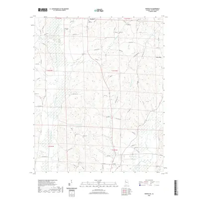
2020 Map of Winfield SE
USGS Topo · Published 2020About this map
Luxapallila Creek and the Sipsey River wind through this corner of Fayette and Marion Counties, defining a landscape of low ridges and stream valleys. The small community of Glen Allen sits on the eastern edge of the quadrangle, while the outskirts of Winfield extend into the northern reaches. This 2020 edition captures a region marked by extensive family-named rural infrastructure and small aviation, notably the Bird Nest Airport. The distribution of numerous cemeteries such as Hopewell Cem, Housh Chapel Cem, and White Springs Cem provides a detailed geographic record for genealogists tracing long-standing local lineages. Transportation is dominated by a web of county roads and crossings like Dodson Xing and Byars Xing, which connect isolated homesteads and farmland across the undulating terrain north of Watkins Lake.
Find a feature on this map
79 named features on this map. Tap any name to fly to it.
Don’t see what you’re looking for? This feature index may not catch every label — zoom into the map to look around manually.
Map Details
Editions of this 2020 Winfield SE Map
This is the sole edition of this map. No revisions or reprints were ever made.
Other maps of this area

1953 · Birmingham
USGS Topo · 1:250,000

1956 · Birmingham
USGS Topo · 1:250,000

1957 · Birmingham
USGS Topo · 1:250,000

1967 · Bankston
USGS Topo · 1:24,000

1967 · Winfield SE
USGS Topo · 1:24,000

1967 · Hubbertville
USGS Topo · 1:24,000
1967 · Glen Allen
USGS Topo · 1:24,000

1967 · Bluff
USGS Topo · 1:24,000

1967 · Fayette
USGS Topo · 1:24,000
1967 · Winfield
USGS Topo · 1:24,000