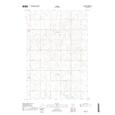
2017 Map of Wing SE
USGS Topo · Published 2017About this map
E Br Apple Cr meanders through the heart of this prairie landscape in Burleigh County, shaping a drainage pattern that defines the local topography. This region of central North Dakota is characterized by its systematic grid of section roads, such as 214th Ave NE and 314th St NE, which serve the agricultural tracts of T141N and T142N. The presence of the Aholan Cem near 201st Ave NE offers a specific point of interest for genealogists and local historians, anchoring the surrounding rural sections to their late-twentieth and early-twenty-first-century community identity. To the south, Rice Lake provides a natural landmark within the township lines, while the network of local connectors like 288th St NE highlights the enduring importance of road access in this sparsely populated farming area.
Find a feature on this map
18 named features on this map. Tap any name to fly to it.
Don’t see what you’re looking for? This feature index may not catch every label — zoom into the map to look around manually.
Map Details
Editions of this 2017 Wing SE Map
This is the sole edition of this map. No revisions or reprints were ever made.
Other maps of this area

1951 · McKenzie
USGS Topo · 1:62,500

1951 · Driscoll
USGS Topo · 1:62,500

1954 · Bismarck
USGS Topo · 1:250,000

1954 · McClusky
USGS Topo · 1:250,000

1958 · Bismarck
USGS Topo · 1:250,000

1958 · McClusky
USGS Topo · 1:250,000

1975 · Sibley Butte
USGS Topo · 1:24,000

1975 · Wing SE
USGS Topo · 1:24,000
1975 · McKenzie NW
USGS Topo · 1:24,000
1975 · Wing SW
USGS Topo · 1:24,000