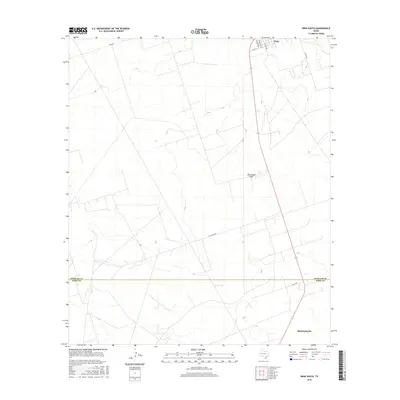
2016 Map of Wink South
USGS Topo · Published 2016About this map
Wink and the northern outskirts of Monahans anchor this 2016 survey of the Permian Basin landscape. The map captures a moment of modern transition across the Winkler and Ward County line, where the arid terrain is defined by a rigorous grid of service roads and petroleum infrastructure. The most significant natural hydrological feature is the ephemeral Monument Draw, which meanders through the central portion of the quadrangle. Local transportation is represented by a network of rural routes including Little Joe Rd and Co Rd 120, providing access across the scrubland between these two West Texas communities. While much of the area appears open, the naming of specific residential and commercial arteries like S Oaklawn Dr and S Standlind Rd in the north indicates the southern expansion of the local settlement.
Find a feature on this map
12 named features on this map. Tap any name to fly to it.
Don’t see what you’re looking for? This feature index may not catch every label — zoom into the map to look around manually.
Map Details
Editions of this 2016 Wink South Map
This is the sole edition of this map. No revisions or reprints were ever made.
Other maps of this area

1954 · Pecos
USGS Topo · 1:250,000

1957 · Pecos
USGS Topo · 1:250,000

1968 · Soda Lake SE
USGS Topo · 1:24,000

1968 · Wink South
USGS Topo · 1:24,000

1968 · Soda Lake NE
USGS Topo · 1:24,000

1969 · Pyote NE
USGS Topo · 1:24,000

1969 · Pyote East
USGS Topo · 1:24,000
1969 · Pyote West
USGS Topo · 1:24,000

1970 · Wink North
USGS Topo · 1:24,000

1970 · Cheyenne Draw SE
USGS Topo · 1:24,000