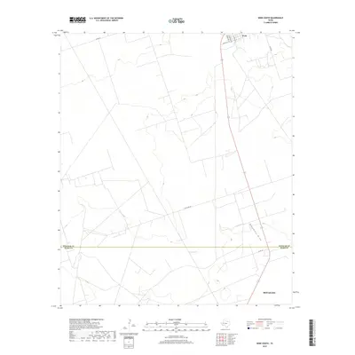
2019 Map of Wink South
USGS Topo · Published 2019About this map
Wink and the northern outskirts of Monahans anchor this Permian Basin landscape, where the administrative boundary between Winkler and Ward Counties cuts through a network of rural routes and industrial pathways. The terrain is characterized by its drainage patterns, most notably Monument Draw, which meanders through the eastern portion of the survey. The grid of roads, including Co Rd 201 and Little Joe Rd, suggests a landscape organized around regional connectivity and resource extraction common to this section of West Texas. Residents and researchers will note the transition from the structured street plan of S Pyote Ave and SW 6th St into the open expanses defined by the local road network, such as Co Rd 120.
Find a feature on this map
12 named features on this map. Tap any name to fly to it.
Don’t see what you’re looking for? This feature index may not catch every label — zoom into the map to look around manually.
Map Details
Editions of this 2019 Wink South Map
This is the sole edition of this map. No revisions or reprints were ever made.
Other maps of this area

1954 · Pecos
USGS Topo · 1:250,000

1957 · Pecos
USGS Topo · 1:250,000

1968 · Soda Lake SE
USGS Topo · 1:24,000

1968 · Wink South
USGS Topo · 1:24,000

1968 · Soda Lake NE
USGS Topo · 1:24,000

1969 · Pyote NE
USGS Topo · 1:24,000

1969 · Pyote East
USGS Topo · 1:24,000
1969 · Pyote West
USGS Topo · 1:24,000

1970 · Wink North
USGS Topo · 1:24,000

1970 · Cheyenne Draw SE
USGS Topo · 1:24,000