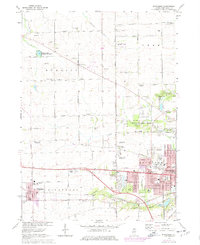
1971 Map of Winnebago
USGS Topo · Published 1977About this map
The expanding western edge of Rockford meets the agricultural heart of Winnebago County in this mid-1970s record of Illinois' rural-to-urban transition. Settlement is anchored by the village of Winnebago and the crossroads of Wempletown, while the surrounding landscape is defined by the North Fork Kent Creek and South Fork Kent Creek. The influence of the postwar era is visible in the cluster of broadcast landmarks, including Radio Tower (WREX-TV) and Radio Tower (WTVO-TV), which stand as vertical anchors across the prairie.
Find a feature on this map
54 named features on this map. Tap any name to fly to it.
Don’t see what you’re looking for? This feature index may not catch every label — zoom into the map to look around manually.
Map Details
Editions of this 1971 Winnebago Map
2 editions found
Other maps of this area

1917 · Kings
USGS Topo · 1:62,500

1918 · Rockford
USGS Topo · 1:62,500

1918 · Kings
USGS Topo · 1:62,500

1922 · Oregon
USGS Topo · 1:62,500

1924 · Oregon
USGS Topo · 1:62,500

1932 · Pecatonica
USGS Topo · 1:62,500

1936 · Pecatonica
USGS Topo · 1:62,500

1938 · Rockford
USGS Topo · 1:62,500

1949 · Camp Grant
USGS Topo · 1:24,000

1949 · Rockford
USGS Topo · 1:24,000