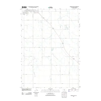
2012 Map of Winner South
USGS Topo · Published 2012About this map
Winner serves as the central hub for this portion of the South Dakota prairie, where the residential grid of the town’s southern edge transitions into expansive agricultural sections. The map highlights key community landmarks such as the Tripp County Fair Grounds and City Park, which anchor the northern corner of the quadrangle. The local geography is defined by the winding paths of Sand Cr, Thunder Cr, and Mud Cr, which cut through the landscape alongside Beaulieu Lake. This 2012 survey illustrates the modern rural infrastructure of the region, featuring a systematic network of section line roads including S Country Club Rd and Co Hwy-3169 that facilitate movement between the town center and the surrounding farmsteads.
Find a feature on this map
38 named features on this map. Tap any name to fly to it.
Don’t see what you’re looking for? This feature index may not catch every label — zoom into the map to look around manually.
Map Details
Editions of this 2012 Winner South Map
This is the sole edition of this map. No revisions or reprints were ever made.
Other maps of this area

1955 · Mitchell
USGS Topo · 1:250,000

1959 · Mitchell
USGS Topo · 1:250,000

1964 · Dallas NW
USGS Topo · 1:24,000

1971 · Colome
USGS Topo · 1:24,000

1971 · Rattlesnake Butte West
USGS Topo · 1:24,000

1982 · Winner North
USGS Topo · 1:25,000

1982 · Winner South
USGS Topo · 1:25,000
1982 · Miller Hill
USGS Topo · 1:25,000
1982 · Wewela NE
USGS Topo · 1:24,000
1982 · Dog Ear Buttes
USGS Topo · 1:25,000