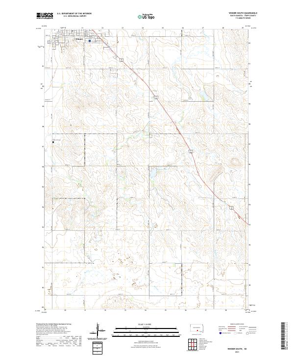
2021 Map of Winner South
USGS Topo · Published 2021About this map
The southern outskirts of Winner transition into the expansive agricultural and grazing lands of Tripp County in this 2021 survey. The street grid of the town center, including Main St and S Country Club Rd, gives way to a network of section-line roads such as 315th Ave and 279th St. This area is defined by its intermittent drainage systems, where Sand Creek and Thunder Creek carve subtle relief through the landscape. A notable site of local heritage is the ZCBJ 237 Cem, reflecting the ethnic fraternal history of the region. Isolated water bodies like Beaulieu Lake dot the terrain, while US Highway 183 serves as the primary corridor connecting these rural townships. The map illustrates the persistent structure of the Public Land Survey System, with township and range lines like t98n r76w organizing the modern ranching and farming economy.
Find a feature on this map
44 named features on this map. Tap any name to fly to it.
Don’t see what you’re looking for? This feature index may not catch every label — zoom into the map to look around manually.
Map Details
Editions of this 2021 Winner South Map
This is the sole edition of this map. No revisions or reprints were ever made.
Other maps of this area

1955 · Mitchell
USGS Topo · 1:250,000

1959 · Mitchell
USGS Topo · 1:250,000

1964 · Dallas NW
USGS Topo · 1:24,000

1971 · Colome
USGS Topo · 1:24,000

1971 · Rattlesnake Butte West
USGS Topo · 1:24,000

1982 · Winner North
USGS Topo · 1:25,000

1982 · Winner South
USGS Topo · 1:25,000
1982 · Miller Hill
USGS Topo · 1:25,000
1982 · Wewela NE
USGS Topo · 1:24,000
1982 · Dog Ear Buttes
USGS Topo · 1:25,000