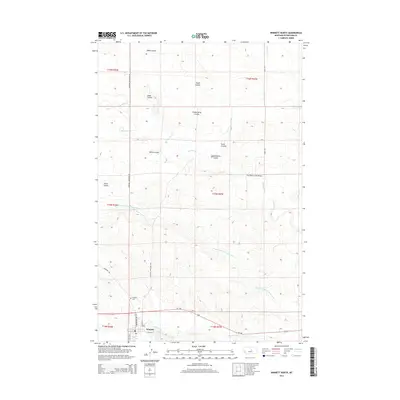
2014 Map of Winnett North
USGS Topo · Published 2014About this map
Winnett serves as the focal point for this section of Petroleum County, where the landscape is defined by an intricate network of drainage and water management. The southern edge of the town is bordered by McDonald Cr, while the surrounding prairie is incised by numerous seasonal watercourses including Shale Coulee, Feldt Coulee, and Chokecherry Coulee. A significant engineering feature of the local agricultural economy is the Winnett Irrigation County Ditch, which snakes through the eastern half of the map, illustrating the historical necessity of water diversion in this semi-arid region. North of the town center, Dovetail Valentine Rd and Gavel Rd provide access to the outlying ranchlands, crossing the Box Elder Cr via the Box Elder Creek Bridge. For those researching local family history, the Winnett Cem is clearly marked at the end of Cemetery Rd, west of the main settlement.
Find a feature on this map
26 named features on this map. Tap any name to fly to it.
Don’t see what you’re looking for? This feature index may not catch every label — zoom into the map to look around manually.
Map Details
Editions of this 2014 Winnett North Map
This is the sole edition of this map. No revisions or reprints were ever made.
Other maps of this area

1954 · Roundup
USGS Topo · 1:250,000

1954 · Lewistown
USGS Topo · 1:250,000

1958 · Roundup
USGS Topo · 1:250,000

1959 · Lewistown
USGS Topo · 1:250,000

1963 · Petrolia Lake
USGS Topo · 1:24,000

1986 · Ingals Dam
USGS Topo · 1:24,000

1986 · Dry Blood Creek West
USGS Topo · 1:24,000

1986 · Winnett North
USGS Topo · 1:24,000

1986 · Dry Blood Creek East
USGS Topo · 1:24,000
1986 · Cat Creek NW
USGS Topo · 1:24,000