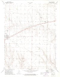
1972 Map of Winona
USGS Topo · Published 1974About this map
The Union Pacific railroad cuts a straight path through the High Plains of Logan County, Kansas, anchoring the small settlements of Winona and Page City. During the early 1970s, this landscape was defined by its vast agricultural expanses and the essential infrastructure of rural aviation, evidenced by the Lowe Landing Strip and Keller Brothers Landing Strip. The drainage patterns of Middle Branch Hackberry Creek and Monument Creek reveal the subtle topography of the region, while the local Gravel Pit indicates the importance of local material extraction for road maintenance in this prairie environment.
Find a feature on this map
14 named features on this map. Tap any name to fly to it.
Don’t see what you’re looking for? This feature index may not catch every label — zoom into the map to look around manually.
Map Details
Editions of this 1972 Winona Map
This is the sole edition of this map. No revisions or reprints were ever made.
Other maps of this area

1954 · Goodland
USGS Topo · 1:250,000

1955 · Scott City
USGS Topo · 1:250,000

1956 · Goodland
USGS Topo · 1:250,000

1957 · Goodland
USGS Topo · 1:250,000

1958 · Scott City
USGS Topo · 1:250,000

1969 · Mc Allaster SE
USGS Topo · 1:24,000

1969 · Russell Springs 2 NE
USGS Topo · 1:24,000

1969 · Mc Allaster NE
USGS Topo · 1:24,000

1972 · Russell Springs
USGS Topo · 1:24,000

1972 · Monument
USGS Topo · 1:24,000