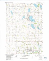
1982 Map of Winsted
USGS Topo · Published 1983About this map
The Crow River South Fork anchors the southern portion of this central Minnesota landscape, where agricultural fields are punctuated by numerous prairie lakes and drained lakebeds. The settlement at Lester Prairie serves as a hub near the river, while Winsted sits to the north along the western shore of Winsted Lake. This 1980s-era geography reflects a long-established rural community, evidenced by several denominational landmarks such as Nylunda Ch, Old Holy Trinity Cem, and St Peter Cem.
Find a feature on this map
51 named features on this map. Tap any name to fly to it.
Don’t see what you’re looking for? This feature index may not catch every label — zoom into the map to look around manually.
Map Details
Editions of this 1982 Winsted Map
This is the sole edition of this map. No revisions or reprints were ever made.
Other maps of this area

1953 · Saint Paul
USGS Topo · 1:250,000

1953 · New Ulm
USGS Topo · 1:250,000

1953 · Saint Cloud
USGS Topo · 1:250,000

1953 · Stillwater
USGS Topo · 1:250,000

1955 · Stillwater
USGS Topo · 1:250,000

1957 · Saint Cloud
USGS Topo · 1:250,000

1957 · New Ulm
USGS Topo · 1:250,000

1957 · Waconia
USGS Topo · 1:62,500

1958 · New Ulm
USGS Topo · 1:250,000

1958 · Stillwater
USGS Topo · 1:250,000
Featured Places
- Winsted, MN
- Lester Prairie, MN
- Bergen Township, MN
- Parkview Mobile Home Park, Lester Prairie
- Woodland Township, MN