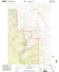
2001 Map of Winston
USGS Topo · Published 2004About this map
The settlement of Winston and its surrounding mining landscape are meticulously detailed at the start of the 21st century. High-altitude drainage systems such as Beaver Creek and the South Fork Pole Creek carve through the Helena National Forest, illustrating the area's complex topography. The map reveals a dense concentration of historical extraction sites, including the East Pacific Mine and Kleinschmidt Mine, alongside numerous adits, mine shafts, and remnant tailings. These features indicate a legacy of hard-rock mining that persisted long after the initial booms of the region. Local land use is further marked by the Whitehead Ranch and various prospects scattered across the higher elevations of Kimber Gulch and Kelly Gulch. Modern infrastructure like a large pipeline and the established boundaries of the Townsend Ranger District intersect with older 4WD trails and springs, showing the layering of industrial utility over the wilderness.
Find a feature on this map
30 named features on this map. Tap any name to fly to it.
Don’t see what you’re looking for? This feature index may not catch every label — zoom into the map to look around manually.
Map Details
Editions of this 2001 Winston Map
This is the sole edition of this map. No revisions or reprints were ever made.
Other maps of this area

1886 · Fort Logan
USGS Topo · 1:250,000

1948 · White Sulphur Springs
USGS Topo · 1:250,000

1950 · Canyon Ferry
USGS Topo · 1:62,500

1950 · Townsend
USGS Topo · 1:62,500

1950 · East Helena
USGS Topo · 1:62,500

1950 · Clancy
USGS Topo · 1:62,500

1958 · White Sulphur Springs
USGS Topo · 1:250,000

1961 · White Sulphur Springs
USGS Topo · 1:250,000

1965 · White Sulphur Springs
USGS Topo · 1:250,000
1972 · Canyon Ferry SW
USGS Topo · 1:24,000