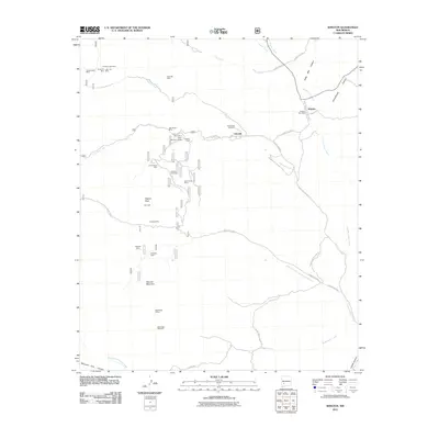
2011 Map of Winston
USGS Topo · Published 2011About this map
Chloride and Winston serve as the primary anchors for this Sierra County landscape, where the legacy of silver and mineral exploration is etched into the terrain. The map meticulously documents a high concentration of mining claims north and south of Mineral Creek, including the Saint Cloud Mines, U.S. Treasury Mine, and the White Mountain Group. These extraction sites are linked by a network of forest service roads and county routes that navigate the complex drainages of Chloride Creek and Cuchillo Negro Creek.
Find a feature on this map
47 named features on this map. Tap any name to fly to it.
Don’t see what you’re looking for? This feature index may not catch every label — zoom into the map to look around manually.
Map Details
Editions of this 2011 Winston Map
This is the sole edition of this map. No revisions or reprints were ever made.
Other maps of this area

1949 · Lookout Mountain
USGS Topo · 1:62,500

1954 · Tularosa
USGS Topo · 1:250,000

1958 · Tularosa
USGS Topo · 1:250,000

1963 · Thumb Tank Peak
USGS Topo · 1:24,000

1963 · Reeds Peak
USGS Topo · 1:24,000

1963 · Sugarloaf Peak
USGS Topo · 1:24,000

1965 · Winston
USGS Topo · 1:24,000

1965 · Iron Mountain
USGS Topo · 1:24,000

1965 · Jaralosa Mountain
USGS Topo · 1:24,000
1965 · Chise
USGS Topo · 1:24,000