1972 Map of Winter
USGS Topo · Published 1975About this map
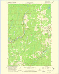
The Chippewa River carves a central path through this Sawyer County landscape, joined from the east by the Brunet River at a series of Rapids. The settlement of Winter serves as a primary hub in the northeast, marked by local infrastructure like the Winter Cem and St Peters Cem. To the southwest, the town of Ojibwa sits near the Ojibwa State Roadside Park, reflecting a region transitioning into recreation and conservation. The conversion of former transportation corridors is evident in the Tuscobia-Park Falls State Trail and an Old RR Grade, tracing the path of earlier logging or transit lines. Smaller waterways like Knapp Creek and Crazy Horse Creek drain the surrounding timberlands, while several Gravel Pits indicate active local industry during the early 1970s.
Find a feature on this map
30 named features on this map. Tap any name to fly to it.
Don’t see what you’re looking for? This feature index may not catch every label — zoom into the map to look around manually.
Map Details
Editions of this 1972 Winter Map
This is the sole edition of this map. No revisions or reprints were ever made.
Other maps of this area

1944 · Exeland
USGS Topo · 1:48,000

1944 · Draper
USGS Topo · 1:48,000

1944 · Radisson
USGS Topo · 1:48,000

1945 · Ingram
USGS Topo · 1:48,000

1947 · Exeland
USGS Topo · 1:48,000

1947 · Ingram
USGS Topo · 1:48,000
1947 · Draper
USGS Topo · 1:48,000
1949 · Radisson
USGS Topo · 1:48,000

1953 · Rice Lake
USGS Topo · 1:250,000

1959 · Rice Lake
USGS Topo · 1:250,000