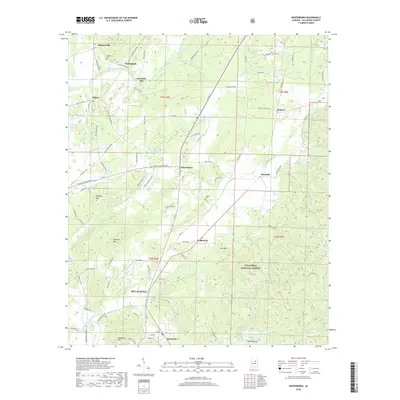
2018 Map of Winterboro
USGS Topo · Published 2018About this map
Talladega National Forest dominates the eastern landscape of this Alabama quadrangle, where the foothills of the Appalachians meet the valley floors. The northern outskirts of Sylacauga and the community of Sycamore mark the southern boundary, while small historic settlements like Winterboro and Nottingham dot the central and northern interior. The terrain is defined by prominent peaks including Mallory Mtn and Heacock Mtn, with the waters of Talladega Creek and Weewoka Cr cutting through the lowlands. Local history is preserved in sites like Kingston Cem and Wilson Cem, alongside the remnants of industrial or agricultural sites such as Reynolds Mill. This mapping shows a transition from the dense woodlands of the national forest to the developed transportation corridors and residential clusters nearing the Talladega County mining and industrial hubs.
Find a feature on this map
100 named features on this map. Tap any name to fly to it.
Don’t see what you’re looking for? This feature index may not catch every label — zoom into the map to look around manually.
Map Details
Editions of this 2018 Winterboro Map
This is the sole edition of this map. No revisions or reprints were ever made.
Other maps of this area

1890 · Talladega
USGS Topo · 1:125,000

1892 · Talladega
USGS Topo · 1:125,000

1915 · Gantts Quarry
USGS Topo · 1:48,000

1917 · Gantts Quarry
USGS Topo · 1:62,500

1943 · Talladega
USGS Topo · 1:62,500

1944 · Goodwater
USGS Topo · 1:62,500

1946 · Talladega
USGS Topo · 1:62,500

1947 · Goodwater
USGS Topo · 1:62,500

1951 · Laniers
USGS Topo · 1:24,000

1953 · Birmingham
USGS Topo · 1:250,000