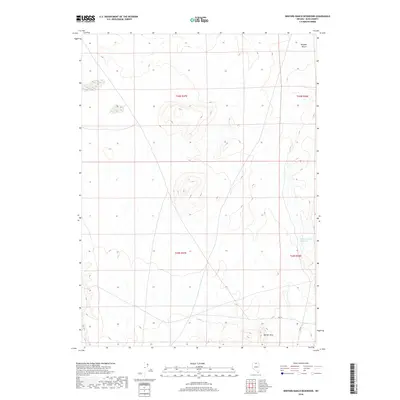
2018 Map of Winters Ranch Reservoir
USGS Topo · Published 2018About this map
The high desert landscape of Elko County is defined here by the arid expanse of the Owyhee Desert and the rising elevations of the Burner Hills in the south. This 2018 survey documents a remote corner of northern Nevada, where water management is critical to the local ranching heritage. The Winters Ranch Reservoir serves as a vital point of interest for those tracking historical water rights and land use in the Great Basin. Transportation through this open range is limited to isolated corridors such as Sssr 18 and Ssr 18, which trace the path of earlier primitive roads. The map illustrates the township and range grid across regions including t43n r47e and t42n r48e, providing a precise reference for those studying historical property boundaries and grazing allotments in this sparsely populated territory.
Find a feature on this map
9 named features on this map. Tap any name to fly to it.
Don’t see what you’re looking for? This feature index may not catch every label — zoom into the map to look around manually.
Map Details
Editions of this 2018 Winters Ranch Reservoir Map
This is the sole edition of this map. No revisions or reprints were ever made.
Other maps of this area

1955 · McDermitt
USGS Topo · 1:250,000

1959 · McDermitt
USGS Topo · 1:250,000

1973 · McCleary Wells
USGS Topo · 1:24,000

1973 · Corral Lake
USGS Topo · 1:24,000

1973 · Haystack Peak
USGS Topo · 1:24,000

1974 · Soldier Cap
USGS Topo · 1:24,000

1974 · Middle Draw Reservoir
USGS Topo · 1:24,000

1974 · Winters Ranch Reservoir
USGS Topo · 1:24,000

1974 · Burner Hills
USGS Topo · 1:24,000

1974 · Desert Ranch
USGS Topo · 1:24,000