
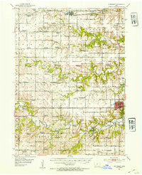
1952 Map of Winterset
USGS Topo · Published 1954About this map
The Middle River and its tributaries carve through the rolling farmland of Madison County, framing the local hub of Winterset. This mid-century survey captures a landscape defined by its rural civic structure, where the square grid of roads is dotted with numerous district schools and community landmarks. Of particular note is Pammel State Park, which preserves a scenic bend of the river and includes the unique Harmon Tunnel, a rare engineering feature in this agricultural setting.
Find a feature on this map
70 named features on this map. Tap any name to fly to it.
Don’t see what you’re looking for? This feature index may not catch every label — zoom into the map to look around manually.
Map Details
Editions of this 1952 Winterset Map
2 editions found
Other maps of this area

1908 · Waukee
USGS Topo · 1:62,500

1949 · Adel
USGS Topo · 1:62,500

1951 · Adel
USGS Topo · 1:62,500

1951 · Osceola
USGS Topo · 1:62,500

1951 · St. Charles
USGS Topo · 1:62,500

1951 · Afton
USGS Topo · 1:62,500

1952 · Panora
USGS Topo · 1:62,500

1954 · Greenfield
USGS Topo · 1:62,500

1954 · Omaha
USGS Topo · 1:250,000

1954 · Des Moines
USGS Topo · 1:250,000