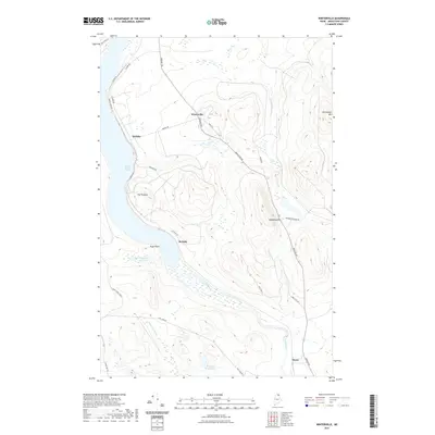
2021 Map of Winterville
USGS Topo · Published 2021About this map
Winterville and the neighboring settlements of Quimby, McNally, and Nixon define this rural landscape in Aroostook County. The North Maine Woods character is evident in the dense network of logging and local roads, such as Aroostook Rd and Fish Lake Rd, which thread between prominent elevations like Hedgehog Mtn and Pennington Mtn. Much of the local activity is oriented toward the water, with Saint Froid Lake dominating the western edge of the quadrangle. The Fish River winds through the southern portion of the sheet, joined by smaller tributaries including Mosquito Brook and Pennington Brook. Landforms like The Pinnacle and Togue Point provide distinctive landmarks for navigating this heavily forested terrain, while the alignment of State Hwy 11 serves as the primary corridor connecting these small communities and remote ponds like Nadeau Pond.
Find a feature on this map
32 named features on this map. Tap any name to fly to it.
Don’t see what you’re looking for? This feature index may not catch every label — zoom into the map to look around manually.
Map Details
Editions of this 2021 Winterville Map
This is the sole edition of this map. No revisions or reprints were ever made.
Other maps of this area

1927 · Square Lake
USGS Topo · 1:48,000

1928 · Eagle Lake
USGS Topo · 1:48,000

1928 · Winterville
USGS Topo · 1:48,000

1929 · Portage
USGS Topo · 1:62,500

1931 · Square Lake
USGS Topo · 1:62,500

1931 · Eagle Lake
USGS Topo · 1:62,500

1931 · Portage
USGS Topo · 1:62,500

1931 · Winterville
USGS Topo · 1:62,500

1953 · Square Lake
USGS Topo · 1:62,500

1953 · Portage
USGS Topo · 1:62,500