
1931 Map of Winterville
USGS Topo · Published 1931About this map
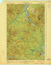
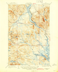
St. Froid Lake dominates the upper corridor of this 1928 survey, where the Bangor and Aroostook railroad follows the shoreline through the settlement of Winterville. The landscape is defined by the network of the Fish River and its numerous tributaries, including Red River and Birch River, which supported the region's logging industry. Remote outposts like Falls Camp and Fourmile Camp are connected by a network of lumbering routes, including the Tote Road and State Highway No. 158.
Find a feature on this map
76 named features on this map. Tap any name to fly to it.
Don’t see what you’re looking for? This feature index may not catch every label — zoom into the map to look around manually.
Map Details
Editions of this 1931 Winterville Map
4 editions found

Other maps of this area

1927 · Square Lake
USGS Topo · 1:48,000

1928 · Eagle Lake
USGS Topo · 1:48,000

1928 · Winterville
USGS Topo · 1:48,000

1929 · Portage
USGS Topo · 1:62,500

1930 · Greenlaw
USGS Topo · 1:48,000

1930 · St Francis
USGS Topo · 1:48,000

1931 · Square Lake
USGS Topo · 1:62,500

1931 · Fish River Lake
USGS Topo · 1:48,000

1931 · Ashland
USGS Topo · 1:48,000

1931 · Mooseleuk Lake
USGS Topo · 1:48,000