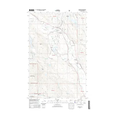
2014 Map of Winthrop
USGS Topo · Published 2014About this map
Winthrop serves as the focal point of this Methow Valley landscape, situated at the confluence of the Methow River and the Chewuch River. The 2014 survey documents a region defined by its water resources and aviation history, featuring the North Cascades Smokejumper Base and the Methow Valley State Airport. To the north and west, the terrain rises toward Patterson Mtn and Elbow Coulee, while the valley floor is dotted with numerous small lakes and ponds, including Patterson Lake, Big Twin Lake, and Moccasin Lake. Local genealogy and land use are represented by the Sullivan Cem and the expansive Winthrop National Fish Hatchery. The road network, including Wa-20, links these natural features with recreational sites like the Silverline Resort Recreational Vehicle Park on the shores of Pearrygin Lake. This map captures the modern footprint of a community deeply integrated with the Okanogan National Forest.
Find a feature on this map
95 named features on this map. Tap any name to fly to it.
Don’t see what you’re looking for? This feature index may not catch every label — zoom into the map to look around manually.
Map Details
Editions of this 2014 Winthrop Map
This is the sole edition of this map. No revisions or reprints were ever made.
Other maps of this area

1899 · Methow
USGS Topo · 1:125,000

1901 · Methow
USGS Topo · 1:125,000

1955 · Concrete
USGS Topo · 1:250,000

1958 · Concrete
USGS Topo · 1:250,000

1962 · Concrete
USGS Topo · 1:250,000

1962 · Mazama
USGS Topo · 1:62,500

1963 · Doe Mountain
USGS Topo · 1:62,500
1969 · Thompson Ridge
USGS Topo · 1:24,000
1969 · Buttermilk Butte
USGS Topo · 1:62,500
1969 · Twisp West
USGS Topo · 1:24,000