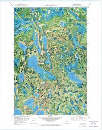
1970 Map of Wirt
USGS Topo · Published 1973About this map
Chippewa National Forest and the Bowstring State Forest dominate this orthophotomap, revealing a complex glaciated landscape defined by an immense density of water bodies. The Big Fork River meanders through the northern section near the small settlement of Wirt, while an Old Railroad Grade cuts through the forest, marking the legacy of the region's logging industry. Major water features including Whitefish Lake, Killdeer Lake, and Sand Lake are shown in precise detail alongside smaller basins like Dogfish Lake and Stone Axe Lake. Local landmarks of the era include the Bass Lake Lookout Tower and the Sand Lake Cem, providing specific points of interest for genealogists and local historians. The map also delineates an Indian Reservation Bdy and a State Forest Bdy, illustrating the various overlapping jurisdictions of the Northwoods at the start of the 1970s.
Find a feature on this map
37 named features on this map. Tap any name to fly to it.
Don’t see what you’re looking for? This feature index may not catch every label — zoom into the map to look around manually.
Map Details
Editions of this 1970 Wirt Map
2 editions found
Other maps of this area

1918 · Zora
USGS Topo · 1:62,500

1919 · Zora
USGS Topo · 1:62,500

1919 · Gemmell
USGS Topo · 1:62,500

1919 · Max
USGS Topo · 1:62,500

1954 · Bemidji
USGS Topo · 1:250,000

1954 · Hibbing
USGS Topo · 1:250,000

1957 · Bemidji
USGS Topo · 1:250,000

1957 · Hibbing
USGS Topo · 1:250,000

1958 · Bemidji
USGS Topo · 1:250,000

1958 · Hibbing
USGS Topo · 1:250,000