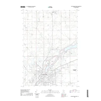
2018 Map of Wisconsin Rapids North
USGS Topo · Published 2018About this map
The Wisconsin River corridor defines the geography of Wood County in this 2018 survey, centered on the urban core of Wisconsin Rapids. The river's path is marked by significant islands such as Big Island, Hunter Island, and Belle Island, which split the channel as it flows south toward Garrison Island. To the northeast, the Biron Flowage backs up behind the settlement of Biron, creating a wide basin that contrasts with the narrower creek beds of Cranberry Creek and Moccasin Creek. The map provides a detailed view of several local burial grounds, including the expansive Forest Hill Cem and Calvary Cem near the city center, as well as outlying sites like Saint Philomena Cem and Holy Rosary Cem. This modern record preserves the complex street grid and industrial layout of the paper-mill region, connecting the rural township of Rudolph to the river's edge.
Find a feature on this map
93 named features on this map. Tap any name to fly to it.
Don’t see what you’re looking for? This feature index may not catch every label — zoom into the map to look around manually.
Map Details
Editions of this 2018 Wisconsin Rapids North Map
This is the sole edition of this map. No revisions or reprints were ever made.
Other maps of this area

1955 · Green Bay
USGS Topo · 1:250,000

1956 · Milladore
USGS Topo · 1:48,000

1956 · Stevens Point
USGS Topo · 1:48,000

1957 · Wisconsin Rapids
USGS Topo · 1:48,000

1957 · Whiting
USGS Topo · 1:48,000

1967 · Wisconsin Rapids
USGS Topo · 1:62,500

1970 · Kellner
USGS Topo · 1:24,000

1970 · Junction City
USGS Topo · 1:24,000
1970 · Sherry
USGS Topo · 1:24,000
1970 · Rocky Run
USGS Topo · 1:24,000