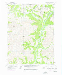
1971 Map of Wiseman B-1
USGS Topo · Published 1977About this map
Wiseman and Coldfoot serve as the primary human outposts in this 1970s interior Alaska landscape, situated along the Middle Fork Koyukuk River. The transition of the wilderness is evident in the presence of The Trans-Alaska Pipeline, which cuts through the region alongside older infrastructure like the Winter Trail. This era of development is juxtaposed with the area's long-standing reliance on extractive industry, indicated by numerous Placer Mines located along tributary waters such as Archibald Creek and Nolan Creek Lake.
Find a feature on this map
61 named features on this map. Tap any name to fly to it.
Don’t see what you’re looking for? This feature index may not catch every label — zoom into the map to look around manually.
Map Details
Editions of this 1971 Wiseman B-1 Map
3 editions found
Other maps of this area

1951 · Chandalar
USGS Topo · 1:250,000

1951 · Wiseman
USGS Topo · 1:250,000

1956 · Chandalar
USGS Topo · 1:250,000

1956 · Wiseman
USGS Topo · 1:250,000

1964 · Wiseman
USGS Topo · 1:250,000

1964 · Chandalar
USGS Topo · 1:250,000

1970 · Wiseman A-1
USGS Topo · 1:63,360
1970 · Chandalar A-6
USGS Topo · 1:63,360

1970 · Wiseman A-2
USGS Topo · 1:63,360

1971 · Wiseman C-2
USGS Topo · 1:63,360