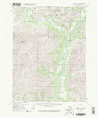
1971 Map of Wiseman B-1
USGS Topo · Published 1977About this map
Wiseman and Coldfoot serve as central points in this Brooks Range landscape during a period of massive infrastructure development. While the historic mining heritage is evident through numerous Placer Mines and Prospects along Nolan Creek and Hammond River, the map records a major shift with The Trans-Alaska Pipeline (under construction) following the Middle Fork of the Koyukuk River. Local geography is defined by prominent heights like Midnight Dome and Smith Creek Dome, which overlook a network of gulches and creeks where gold seekers once labored. Evidence of the remote nature of the region is seen in the Landing Strip near Wiseman and the scattered Cabin sites. The transition from early 20th-century gold mining to the modern energy era is captured here, showing the physical path of the pipeline as it began to alter the northern interior.
Find a feature on this map
64 named features on this map. Tap any name to fly to it.
Don’t see what you’re looking for? This feature index may not catch every label — zoom into the map to look around manually.
Map Details
Editions of this 1971 Wiseman B-1 Map
3 editions found
Other maps of this area

1951 · Chandalar
USGS Topo · 1:250,000

1951 · Wiseman
USGS Topo · 1:250,000

1956 · Chandalar
USGS Topo · 1:250,000

1956 · Wiseman
USGS Topo · 1:250,000

1964 · Wiseman
USGS Topo · 1:250,000

1964 · Chandalar
USGS Topo · 1:250,000

1970 · Wiseman A-1
USGS Topo · 1:63,360
1970 · Chandalar A-6
USGS Topo · 1:63,360

1970 · Wiseman A-2
USGS Topo · 1:63,360

1971 · Wiseman C-2
USGS Topo · 1:63,360