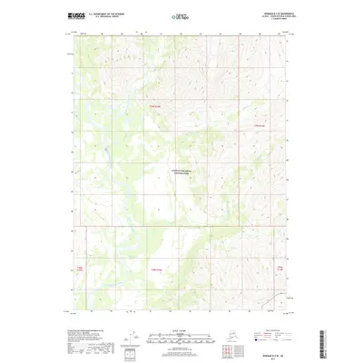
2017 Map of Wiseman B-2 SE
USGS Topo · Published 2017About this map
Gates of the Arctic National Park encompasses this entire northern landscape, defined by its high-altitude topography and winding river systems. The North Fork Koyukuk River serves as the primary drainage, carving a broad valley floor as it flows southward past the turbulent Squaw Rapids. The hydrologic network is further shaped by the Glacier River, which feeds into the valley from the north, and several significant tributaries including Horse Cr and Rock Cr. This 2017 survey reflects the protected wilderness character of the Yukon-Koyukuk region, illustrating a terrain devoid of permanent roads or structures, where the land's form is dictated entirely by its glacial and fluvial history.
Find a feature on this map
11 named features on this map. Tap any name to fly to it.
Don’t see what you’re looking for? This feature index may not catch every label — zoom into the map to look around manually.
Map Details
Editions of this 2017 Wiseman B-2 SE Map
This is the sole edition of this map. No revisions or reprints were ever made.
Other maps of this area

1951 · Wiseman
USGS Topo · 1:250,000

1956 · Wiseman
USGS Topo · 1:250,000

1964 · Wiseman
USGS Topo · 1:250,000

1970 · Wiseman A-1
USGS Topo · 1:63,360

1970 · Wiseman A-2
USGS Topo · 1:63,360
1971 · Wiseman B-1
USGS Topo · 1:63,360
1971 · Wiseman B-2
USGS Topo · 1:63,360
2017 · Wiseman A-2 NE
USGS Topo · 1:25,000
2017 · Wiseman A-2 NW
USGS Topo · 1:25,000
2017 · Wiseman A-1 NW
USGS Topo · 1:25,000