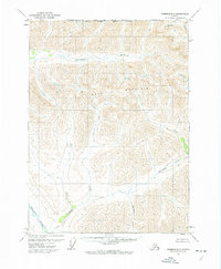
1971 Map of Wiseman D-3
USGS Topo · Published 1974About this map
Gray Mountain dominates the central landscape of this interior Alaskan survey, serving as a massive topographical anchor between several major drainage systems. In the early 1970s, this region remained a wilderness of high ridgelines and deep glacial valleys, notably free of established roads or permanent settlements. The Tinayguk River cuts through the western and northern reaches, fed by a network of high-altitude streams including Wolf Creek and Cladonia Creek.
Find a feature on this map
10 named features on this map. Tap any name to fly to it.
Don’t see what you’re looking for? This feature index may not catch every label — zoom into the map to look around manually.
Map Details
Editions of this 1971 Wiseman D-3 Map
This is the sole edition of this map. No revisions or reprints were ever made.
Other maps of this area

1951 · Chandler Lake
USGS Topo · 1:250,000

1951 · Wiseman
USGS Topo · 1:250,000

1956 · Wiseman
USGS Topo · 1:250,000

1956 · Chandler Lake
USGS Topo · 1:250,000

1964 · Wiseman
USGS Topo · 1:250,000

1964 · Chandler Lake
USGS Topo · 1:250,000
1971 · Chandler Lake A-2
USGS Topo · 1:63,360

1971 · Wiseman C-2
USGS Topo · 1:63,360

1971 · Chandler Lake A-3
USGS Topo · 1:63,360

1971 · Wiseman C-4
USGS Topo · 1:63,360