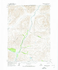
1971 Map of Wiseman D-5
USGS Topo · Published 1974About this map
The John River valley serves as the central corridor of this Brooks Range landscape, where the seasonal Winter Road follows the riverbanks through unsurveyed wilderness. The confluence of the Hunt Fork John River creates a significant drainage point in the southern half of the sheet, surrounded by prominent peaks like Cairn Mountain and the high point at Yenituk. This 1971 survey illustrates a remote Arctic environment defined by its complex waterway network, including Pamichtuk Lake and its outlet, Mushushuluk Cr. The North Slope Borough Boundary bisects the northern reaches, marking a political division across a terrain where only landmarks like Publituk and Kukluk anchor the geography. The map provides a look at the region before large-scale infrastructure, recording the natural drainage patterns of Yenituk Creek and Till Creek as they feed the primary river system.
Find a feature on this map
15 named features on this map. Tap any name to fly to it.
Don’t see what you’re looking for? This feature index may not catch every label — zoom into the map to look around manually.
Map Details
Editions of this 1971 Wiseman D-5 Map
This is the sole edition of this map. No revisions or reprints were ever made.
Other maps of this area

1951 · Chandler Lake
USGS Topo · 1:250,000

1951 · Wiseman
USGS Topo · 1:250,000

1956 · Wiseman
USGS Topo · 1:250,000

1956 · Chandler Lake
USGS Topo · 1:250,000

1964 · Wiseman
USGS Topo · 1:250,000

1964 · Chandler Lake
USGS Topo · 1:250,000

1971 · Wiseman C-4
USGS Topo · 1:63,360
1971 · Wiseman D-4
USGS Topo · 1:63,360

1971 · Wiseman C-5
USGS Topo · 1:63,360
1986 · Wiseman C-6
USGS Topo · 1:63,360