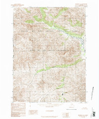
1986 Map of Wiseman C-6
USGS Topo · Published 1986About this map
Gates of the Arctic National Park and the Gates of the Arctic Wilderness dominate this Brooks Range landscape as documented in the mid-1980s. This survey, compiled from 1973 aerial photography, reveals a region defined entirely by its hydrological network and extreme topography, completely devoid of roads or trails. The drainage patterns of Shukokluk Creek and Wolverine Creek carve through the high terrain, eventually giving way to the Shukok Creek system in the south. The western edge of the map is defined by the West Boundary Fairbanks Meridian, a critical surveying line in the Alaskan interior. This provisional edition serves as a primary record of the park's early years, capturing the state of the wilderness before later climate shifts or modern recreational impacts altered these remote watersheds.
Find a feature on this map
6 named features on this map. Tap any name to fly to it.
Don’t see what you’re looking for? This feature index may not catch every label — zoom into the map to look around manually.
Map Details
Editions of this 1986 Wiseman C-6 Map
This is the sole edition of this map. No revisions or reprints were ever made.
Other maps of this area

1951 · Survey Pass
USGS Topo · 1:250,000

1951 · Wiseman
USGS Topo · 1:250,000

1956 · Wiseman
USGS Topo · 1:250,000

1956 · Survey Pass
USGS Topo · 1:250,000

1964 · Survey Pass
USGS Topo · 1:250,000

1964 · Wiseman
USGS Topo · 1:250,000

1966 · Survey Pass
USGS Topo · 1:250,000

1971 · Wiseman C-5
USGS Topo · 1:63,360
1971 · Wiseman B-5
USGS Topo · 1:63,360
1971 · Wiseman D-5
USGS Topo · 1:63,360