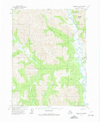
1971 Map of Wiseman B-5
USGS Topo · Published 1974About this map
The John River valley defines this interior landscape, serving as a primary corridor through high-altitude terrain in northern Alaska. In the early 1970s, the area remained largely undeveloped, with a notable Winter Road providing seasonal access along the river's eastern banks. This ephemeral transportation route connects the isolated Landing Strip Crevice and several mountain drainages, including Gunsight Creek and Bar Creek. The presence of a lone Cabin south of Rock Creek and the landing strip at Crevice Creek suggests a reliance on small-craft aviation and seasonal trapping or subsistence living. A complex drainage network feeds the river, featuring the Malamute Fork John River and Sixtymile Creek, while prominent elevations like Gunsight Mountain and the Sentinels stand as navigational landmarks for travelers moving through the Brooks Range foothills.
Find a feature on this map
21 named features on this map. Tap any name to fly to it.
Don’t see what you’re looking for? This feature index may not catch every label — zoom into the map to look around manually.
Map Details
Editions of this 1971 Wiseman B-5 Map
This is the sole edition of this map. No revisions or reprints were ever made.
Other maps of this area

1951 · Wiseman
USGS Topo · 1:250,000

1956 · Wiseman
USGS Topo · 1:250,000

1964 · Wiseman
USGS Topo · 1:250,000
1970 · Wiseman A-6
USGS Topo · 1:63,360

1970 · Wiseman A-4
USGS Topo · 1:63,360

1970 · Wiseman A-5
USGS Topo · 1:63,360

1971 · Wiseman C-4
USGS Topo · 1:63,360

1971 · Wiseman C-5
USGS Topo · 1:63,360
1971 · Wiseman B-4
USGS Topo · 1:63,360
1986 · Wiseman C-6
USGS Topo · 1:63,360