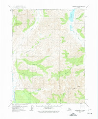
1971 Map of Wiseman B-4
USGS Topo · Published 1974About this map
Wild Lake serves as a central landmark in this remote Alaskan landscape, where the Wild River and John River systems carve through the interior. The mapping reflects a region defined by seasonal access and subsistence, with isolated cabins dotted along the watercourses and shoreline. Transportation is primarily limited to a Winter Trail and a Winter Road, signaling a reliance on frozen conditions for heavy movement across the drainage basins of Crevice Creek and Allen River. This 1971 survey captures the topography of the Brooks Range foothills just as photogrammetric methods were being refined to document these northern reaches. The drainage patterns of named tributaries like Bultrun Creek and McCamant Creek suggest a landscape used by hunters, trappers, and early mineral prospectors who followed the narrow valleys between unnamed peaks and ridges.
Find a feature on this map
17 named features on this map. Tap any name to fly to it.
Don’t see what you’re looking for? This feature index may not catch every label — zoom into the map to look around manually.
Map Details
Editions of this 1971 Wiseman B-4 Map
This is the sole edition of this map. No revisions or reprints were ever made.
Other maps of this area

1951 · Wiseman
USGS Topo · 1:250,000

1956 · Wiseman
USGS Topo · 1:250,000

1964 · Wiseman
USGS Topo · 1:250,000

1970 · Wiseman A-4
USGS Topo · 1:63,360

1970 · Wiseman A-3
USGS Topo · 1:63,360

1970 · Wiseman A-5
USGS Topo · 1:63,360

1971 · Wiseman C-4
USGS Topo · 1:63,360
1971 · Wiseman B-3
USGS Topo · 1:63,360

1971 · Wiseman C-5
USGS Topo · 1:63,360
1971 · Wiseman B-5
USGS Topo · 1:63,360