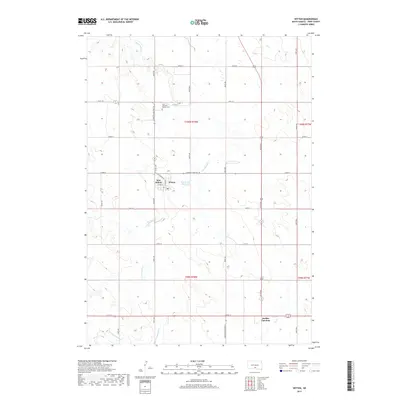
2017 Map of Witten
USGS Topo · Published 2017About this map
Witten and the adjacent settlement of New Witten occupy the heart of this South Dakota prairie landscape, situated along the corridor of S Dakota Highway 44. The area is defined by the headwaters and branches of Cottonwood Cr, including the distinct western and eastern forks known as W Cottonwood Cr and E Cottonwood Cr. Local water management is visible at the Witten Dam Reservoir, providing a vital resource for this agricultural region. To the north of the town center, Saint John the Baptist Cem serves as a significant genealogical landmark for Tripp County researchers. The southern portion of the quadrangle includes the intersection at Jordan Junction, where the state highway system links this rural community to the broader ranching and farming network of the Rosebud country.
Find a feature on this map
32 named features on this map. Tap any name to fly to it.
Don’t see what you’re looking for? This feature index may not catch every label — zoom into the map to look around manually.
Map Details
Editions of this 2017 Witten Map
This is the sole edition of this map. No revisions or reprints were ever made.
Other maps of this area

1955 · Martin
USGS Topo · 1:250,000

1955 · Mitchell
USGS Topo · 1:250,000

1958 · Martin
USGS Topo · 1:250,000

1959 · Mitchell
USGS Topo · 1:250,000

1982 · Presho 4 SE
USGS Topo · 1:25,000

1982 · Witten SE
USGS Topo · 1:25,000

1982 · Two Nation Creek
USGS Topo · 1:25,000

1982 · Witten
USGS Topo · 1:25,000
1982 · Miller Hill
USGS Topo · 1:25,000

1982 · Witten SW
USGS Topo · 1:25,000