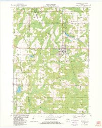
1982 Map of Wittenberg
USGS Topo · Published 1982About this map
Wittenberg stands as the central hub of this 1982 survey, situated at the junction of several key rail and road corridors along the South Branch Embarrass River. The landscape is a complex network of wetlands and small glacial lakes, including Lilly Lake and Wilson Lake, which define the local topography. The Chicago and North Western railroad lines bisect the area, connecting the villages of Eland and Wittenberg to the wider dairy and timber regions of central Wisconsin. Cultural and social landmarks like the Homme Home for Boys and the unique Potch-Chee-Nunk site provide a look into the institutional and local history of the era. A high density of cemeteries, such as Holy Family Cem and Bethany Cem, alongside rural sites like Kingdom Hall, makes this sheet a valuable resource for tracing family roots in the eastern reaches of Marathon and Shawano Counties.
Find a feature on this map
58 named features on this map. Tap any name to fly to it.
Don’t see what you’re looking for? This feature index may not catch every label — zoom into the map to look around manually.
Map Details
Editions of this 1982 Wittenberg Map
This is the sole edition of this map. No revisions or reprints were ever made.
Other maps of this area

1899 · Wausau
USGS Topo · 1:125,000

1902 · Wausau
USGS Topo · 1:125,000

1953 · Hatley
USGS Topo · 1:48,000

1954 · Wittenberg
USGS Topo · 1:48,000

1955 · Tigerton
USGS Topo · 1:48,000

1955 · Rosholt
USGS Topo · 1:48,000

1955 · Green Bay
USGS Topo · 1:250,000

1964 · Wittenberg
USGS Topo · 1:62,500

1964 · Hatley
USGS Topo · 1:62,500

1969 · Rosholt
USGS Topo · 1:24,000