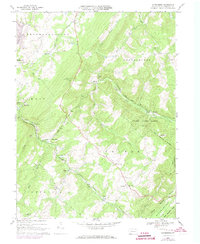
1967 Map of Wittenberg
USGS Topo · Published 1973About this map
Savage Mtn and Big Savage Mtn dominate the southern topography of this Somerset County landscape, where the ridges of the Allegheny Mountains forced a complex rail-and-water network. The Baltimore and Ohio and Western Maryland railroads traverse the terrain, passing through significant local junctions like Sand Patch and Mance. This mid-century survey reveals a rural economy shaped by timber and milling, evidenced by settlements like Hays Mill, Berkleys Mill, and Warrens Mill. Spiritual and community life centers on small mountain congregations, including St Johns Ch and White Oak Ch near the village of Wittenberg. In the north, a Strip Mine and the Mt Zion-Hays Dam indicate industrial and water management efforts, while the Hays Mill Lookout Tower stands as a sentinel over the surrounding timberlands and State Game Lands No 82.
Find a feature on this map
59 named features on this map. Tap any name to fly to it.
Don’t see what you’re looking for? This feature index may not catch every label — zoom into the map to look around manually.
Map Details
Editions of this 1967 Wittenberg Map
4 editions found
Other maps of this area

1898 · Frostburg
USGS Topo · 1:62,500

1899 · Grantsville
USGS Topo · 1:62,500

1901 · Frostburg
USGS Topo · 1:62,500

1904 · Grantsville
USGS Topo · 1:62,500

1908 · Frostburg
USGS Topo · 1:62,500

1921 · Meyersdale
USGS Topo · 1:62,500

1923 · Berlin
USGS Topo · 1:48,000

1929 · Berlin
USGS Topo · 1:62,500

1939 · Meyersdale
USGS Topo · 1:62,500

1944 · Berlin
USGS Topo · 1:62,500
Featured Places
- Callimont, PA
- Southampton Township, PA
- Warrens Mill, Greenville Township
- Hays Mill, Brothersvalley Township
- Brothersvalley Township, PA