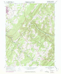
1967 Map of Wittenburg
USGS Topo · Published 1975About this map
The Baltimore and Ohio and Western Maryland railroads define the rugged industrial character of Somerset County in this 1960s study. The topography is dominated by the massive ridge of Big Savage Mtn, which necessitates the heavy infrastructure of the Sand Patch Tunnel and an adjacent Air Shaft to manage the grade. Small settlements and industrial outposts like Sand Patch, Mance, and Philson are tucked along the winding courses of Wills Creek and Flaugherty Creek.
Find a feature on this map
50 named features on this map. Tap any name to fly to it.
Don’t see what you’re looking for? This feature index may not catch every label — zoom into the map to look around manually.
Map Details
Editions of this 1967 Wittenburg Map
4 editions found
Other maps of this area

1898 · Frostburg
USGS Topo · 1:62,500

1899 · Grantsville
USGS Topo · 1:62,500

1901 · Frostburg
USGS Topo · 1:62,500

1904 · Grantsville
USGS Topo · 1:62,500

1908 · Frostburg
USGS Topo · 1:62,500

1921 · Meyersdale
USGS Topo · 1:62,500

1923 · Berlin
USGS Topo · 1:48,000

1929 · Berlin
USGS Topo · 1:62,500

1939 · Meyersdale
USGS Topo · 1:62,500

1944 · Berlin
USGS Topo · 1:62,500
Featured Places
- Callimont, PA
- Southampton Township, PA
- Warrens Mill, Greenville Township
- Hays Mill, Brothersvalley Township
- Brothersvalley Township, PA