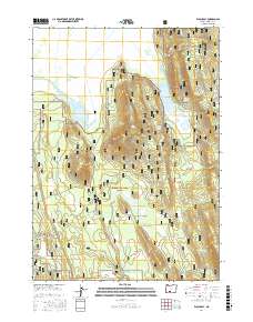
2017 Map of Wocus Bay
USGS Topo · Published 2017About this map
Klamath Marsh National Wildlife Refuge dominates the northern landscape of this map, where the Williamson River feeds into the expansive Klamath Marsh. This aquatic environment is characterized by large, shallow bodies of water including Wocus Bay and Little Wocus Bay, which likely take their name from the wocus lily once harvested here. The terrain transitions from these wetlands into the timbered slopes of the Winema National Forest, punctuated by volcanic features like Wocus Butte and Little Wocus Butte.
Find a feature on this map
27 named features on this map. Tap any name to fly to it.
Don’t see what you’re looking for? This feature index may not catch every label — zoom into the map to look around manually.
Map Details
Editions of this 2017 Wocus Bay Map
This is the sole edition of this map. No revisions or reprints were ever made.
Other maps of this area

1889 · Klamath
USGS Topo · 1:250,000

1894 · Klamath
USGS Topo · 1:250,000

1955 · Klamath Falls
USGS Topo · 1:250,000

1956 · Calimus Butte
USGS Topo · 1:62,500

1957 · Chiloquin
USGS Topo · 1:62,500

1957 · Klamath Marsh
USGS Topo · 1:62,500

1957 · Lenz
USGS Topo · 1:62,500

1958 · Klamath Falls
USGS Topo · 1:250,000

1980 · Williamson River
USGS Topo · 1:100,000
1988 · Applegate Butte
USGS Topo · 1:24,000