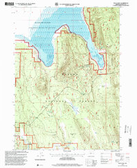
1998 Map of Wocus Bay
USGS Topo · Published 2000About this map
Klamath Marsh National Wildlife Refuge dominates the northwestern portion of this 1990s landscape, where the Williamson River feeds into the expansive wetlands of the Klamath Marsh. The geography is defined by the contrast between these low-lying aquatic environments and the prominent volcanic rises of Wocus Butte and Little Wocus Butte. Within the Winema National Forest, a network of springs and meadows suggests a landscape managed for both timber and natural preservation. Notable water sources such as John Cole Spring, Dice Crane Spring, and Whitehouse Spring are scattered across the terrain, leading toward open areas like Wilson Flats and Soloman Flat. This survey captures the region as the Forest Service and USGS updated the management boundaries for the wildlife refuge and national forest lands, preserving the specific locations of remote meadows like Mullhayes Meadow and Yoss Creek Meadow.
Find a feature on this map
27 named features on this map. Tap any name to fly to it.
Don’t see what you’re looking for? This feature index may not catch every label — zoom into the map to look around manually.
Map Details
Editions of this 1998 Wocus Bay Map
This is the sole edition of this map. No revisions or reprints were ever made.
Other maps of this area

1889 · Klamath
USGS Topo · 1:250,000

1894 · Klamath
USGS Topo · 1:250,000

1955 · Klamath Falls
USGS Topo · 1:250,000

1956 · Calimus Butte
USGS Topo · 1:62,500

1957 · Chiloquin
USGS Topo · 1:62,500

1957 · Klamath Marsh
USGS Topo · 1:62,500

1957 · Lenz
USGS Topo · 1:62,500

1958 · Klamath Falls
USGS Topo · 1:250,000

1980 · Williamson River
USGS Topo · 1:100,000
1988 · Applegate Butte
USGS Topo · 1:24,000