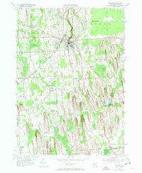
1953 Map of Wolcott
USGS Topo · Published 1955About this map
Wolcott stands as a central hub in Wayne County, where the village and its surrounding rural hamlets follow a landscape defined by the distinct drumlins of the Ontario Lake Plain. The terrain is deeply marked by north-south ridges that channel Wolcott Creek and its tributaries, influencing the layout of local infrastructure like the New York Central Road. Small, specialized clusters such as Rice Mill and Furnace Village indicate an early industrial base tied to water power and local resources, while numerous family-named landmarks like Pangburn Corners and Stewart Corners define the residential geography of the era.
Find a feature on this map
43 named features on this map. Tap any name to fly to it.
Don’t see what you’re looking for? This feature index may not catch every label — zoom into the map to look around manually.
Map Details
Editions of this 1953 Wolcott Map
3 editions found
Other maps of this area

1900 · Oswego
USGS Topo · 1:62,500

1902 · Sodus Bay
USGS Topo · 1:62,500

1902 · Clyde
USGS Topo · 1:62,500

1902 · Weedsport
USGS Topo · 1:62,500

1943 · Lyons
USGS Topo · 1:31,680

1943 · Montezuma
USGS Topo · 1:31,680

1943 · Sodus Point
USGS Topo · 1:31,680

1943 · Savannah
USGS Topo · 1:31,680

1943 · Fair Haven
USGS Topo · 1:31,680

1943 · Wolcott
USGS Topo · 1:31,680