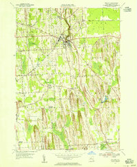
1953 Map of Wolcott
USGS Topo · Published 1974About this map
Wolcott stands as the primary hub in this mid-century portrait of Wayne County, where the village grid meets the winding course of Wolcott Creek. The landscape is defined by its agricultural character and numerous named crossroads, including Stewart Corners, Lockwood Corners, and Pangburn Corners. To the south, South Butler anchor the map near the marshy expanses of Tamarack Swamp. Local industry and heritage are evident in place names like Rice Mill and Furnace Village, while the New York Central railroad provides the vital transportation artery across the northern section of the sheet.
Find a feature on this map
39 named features on this map. Tap any name to fly to it.
Don’t see what you’re looking for? This feature index may not catch every label — zoom into the map to look around manually.
Map Details
Editions of this 1953 Wolcott Map
3 editions found
Other maps of this area

1900 · Oswego
USGS Topo · 1:62,500

1902 · Sodus Bay
USGS Topo · 1:62,500

1902 · Clyde
USGS Topo · 1:62,500

1902 · Weedsport
USGS Topo · 1:62,500

1943 · Lyons
USGS Topo · 1:31,680

1943 · Montezuma
USGS Topo · 1:31,680

1943 · Sodus Point
USGS Topo · 1:31,680

1943 · Savannah
USGS Topo · 1:31,680

1943 · Fair Haven
USGS Topo · 1:31,680

1943 · Wolcott
USGS Topo · 1:31,680