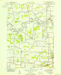
1950 Map of Wolcottsville
USGS Topo · Published 1950About this map
Tonawanda Creek winds across a landscape defined by the intersection of rural townships and early mid-century infrastructure. This area, spanning the border of Niagara and Erie Counties, shows a dense network of district schools including School No 7 and School No 10, reflecting the decentralized education system before widespread consolidation. The village of Akron serves as a primary hub in the southeast, where the New York Central Railroad corridor meets the industrial presence of a Sewage Disposal facility and the complex hydrology of Murder Creek. Smaller settlements like Wolcottsville and East Clarence are connected by a grid of named local routes such as Lapp Road and Meahl Road. The map also captures several local burial grounds like Danser Cemetery and Eldridge Cemetery, providing essential data for those tracing the early families of Newstead and Royalton.
Find a feature on this map
50 named features on this map. Tap any name to fly to it.
Don’t see what you’re looking for? This feature index may not catch every label — zoom into the map to look around manually.
Map Details
Editions of this 1950 Wolcottsville Map
This is the sole edition of this map. No revisions or reprints were ever made.
Other maps of this area

1897 · Medina
USGS Topo · 1:62,500

1897 · Lockport
USGS Topo · 1:62,500

1899 · Niagara
USGS Topo · 1:125,000

1902 · Lockport
USGS Topo · 1:62,500

1905 · Attica
USGS Topo · 1:62,500

1905 · Depew
USGS Topo · 1:62,500

1905 · Lockport
USGS Topo · 1:62,500

1948 · Depew
USGS Topo · 1:62,500

1948 · Lockport
USGS Topo · 1:62,500

1949 · Attica
USGS Topo · 1:62,500