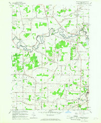
1965 Map of Wolcottsville
USGS Topo · Published 1967About this map
Tonawanda Creek meanders along the border of Niagara and Erie Counties, defining a landscape of wetlands and small agricultural hamlets in the mid-1960s. The village of Wolcottsville sits at the northern edge, supported by landmarks like Trinity Ch and St Michaels Ch, while further south the terrain rises toward the Ledge near Akron. This survey captures a transitional moment for the region’s rural character, showing the intersections of early transit routes and local industry, from the New York Central Railroad corridor to active Quarry and Mine sites.
Find a feature on this map
83 named features on this map. Tap any name to fly to it.
Don’t see what you’re looking for? This feature index may not catch every label — zoom into the map to look around manually.
Map Details
Editions of this 1965 Wolcottsville Map
This is the sole edition of this map. No revisions or reprints were ever made.
Other maps of this area

1897 · Medina
USGS Topo · 1:62,500

1897 · Lockport
USGS Topo · 1:62,500

1899 · Niagara
USGS Topo · 1:125,000

1902 · Lockport
USGS Topo · 1:62,500

1905 · Attica
USGS Topo · 1:62,500

1905 · Depew
USGS Topo · 1:62,500

1905 · Lockport
USGS Topo · 1:62,500

1948 · Depew
USGS Topo · 1:62,500

1948 · Lockport
USGS Topo · 1:62,500

1949 · Attica
USGS Topo · 1:62,500