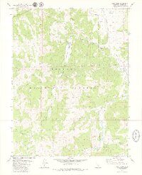
1979 Map of Wolf Creek
USGS Topo · Published 1979About this map
Toiyabe National Forest dominates this high-altitude landscape of Alpine County, where the East Fork Carson River carves through deep canyons and alpine valleys. The topography is defined by the convergence of the Wolf Creek and Silver King Creek drainages, creating a network of natural corridors used for seasonal movement. Human presence is marked by isolated outposts like Wolf Creek Camp and the higher-altitude Vaquero Camp, while the Dixon Mine suggests the region's historical mineral exploration. In the southeastern corner, the landscape opens into Dumonts Meadows near the Soda Springs Station, a key waypoint along the pack trails. This 1970s survey captures the intricate network of Pack Trails and Jeep Trails that provided access to the area's granite peaks and meadows before more modern infrastructure reached these interior reaches of the Sierra Nevada.
Find a feature on this map
30 named features on this map. Tap any name to fly to it.
Don’t see what you’re looking for? This feature index may not catch every label — zoom into the map to look around manually.
Map Details
Editions of this 1979 Wolf Creek Map
3 editions found
Other maps of this area

1889 · Markleeville
USGS Topo · 1:125,000

1891 · Markleeville
USGS Topo · 1:125,000

1893 · Markleeville
USGS Topo · 1:125,000

1896 · Dardanelles
USGS Topo · 1:125,000

1898 · Dardanelles
USGS Topo · 1:125,000

1948 · Walker Lake
USGS Topo · 1:250,000

1954 · Lost Cannon Peak
USGS Topo · 1:24,000

1956 · Topaz Lake
USGS Topo · 1:62,500

1956 · Markleeville
USGS Topo · 1:62,500

1956 · Dardanelles Cone
USGS Topo · 1:62,500