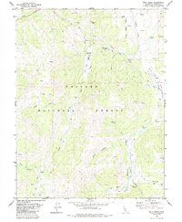
1979 Map of Wolf Creek
USGS Topo · Published 1985About this map
Toiyabe National Forest encompasses this high-altitude landscape in Alpine County, where the East Fork Carson River and Wolf Creek carve through deep canyons and alpine meadows. The 1970s topography highlights a network of pack and jeep trails that supported seasonal activities at sites like Vaquero Camp, Wolf Creek Camp, and the more permanent Soda Springs Station. These routes follow the natural corridors of Bagley Valley and Silver King Valley, connecting remote water sources and high peaks.
Find a feature on this map
29 named features on this map. Tap any name to fly to it.
Don’t see what you’re looking for? This feature index may not catch every label — zoom into the map to look around manually.
Map Details
Editions of this 1979 Wolf Creek Map
3 editions found
Other maps of this area

1889 · Markleeville
USGS Topo · 1:125,000

1891 · Markleeville
USGS Topo · 1:125,000

1893 · Markleeville
USGS Topo · 1:125,000

1896 · Dardanelles
USGS Topo · 1:125,000

1898 · Dardanelles
USGS Topo · 1:125,000

1948 · Walker Lake
USGS Topo · 1:250,000

1954 · Lost Cannon Peak
USGS Topo · 1:24,000

1956 · Topaz Lake
USGS Topo · 1:62,500

1956 · Markleeville
USGS Topo · 1:62,500

1956 · Dardanelles Cone
USGS Topo · 1:62,500