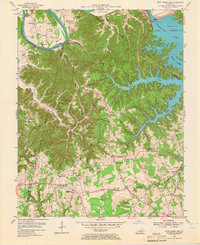
1953 Map of Wolf Creek Dam
USGS Topo · Published 1966About this map
Lake Cumberland dominates the upper half of this map, its winding fingers filling the valleys of the West Fork and Middle Fork following the completion of the Wolf Creek Dam. The landscape reveals a transition from the broad agricultural bottoms of the Cumberland River, such as Wells Bottom and Rockhouse Bottom, to the high ridges of Clinton County. Significant local history is preserved in the network of rural schools and churches that once served these upland communities, including Myers Ridge Sch, Fairland Sch, and Lands Chapel Ch. Evidence of early industry is visible in the scattered oil wells near Desda Ridge and Willis Creek. The village of Seventy Six is marked near the distinctive Seventy Six Falls, where the river's path is interrupted by the dramatic drop into the valley below.
Find a feature on this map
68 named features on this map. Tap any name to fly to it.
Don’t see what you’re looking for? This feature index may not catch every label — zoom into the map to look around manually.
Map Details
Editions of this 1953 Wolf Creek Dam Map
2 editions found
Other maps of this area

1924 · Lillydale
USGS Topo · 1:62,500

1926 · Lillydale
USGS Topo · 1:62,500

1929 · Lillydale
USGS Topo · 1:62,500

1929 · Byrdstown
USGS Topo · 1:62,500

1953 · Amandaville
USGS Topo · 1:24,000

1953 · Burkesville
USGS Topo · 1:24,000

1953 · Wolf Creek Dam
USGS Topo · 1:24,000

1953 · Creelsboro
USGS Topo · 1:24,000

1953 · Jamestown
USGS Topo · 1:24,000

1954 · Frogue
USGS Topo · 1:24,000